Lake Inawashiro

Lake Inawashiro

Japan's fourth-largest freshwater lake, Lake Inawashiro is situated in Bandai Asahi National Park. It is also known as the “Heavenly Mirror Lake” and has a surface area of 104 square kilometers! The combination of Lake Inawashiro and Mt. Bandai form one of Aizu's representative landscapes. And being less than three hours from Tokyo by shinkansen and local train means that you have easy access from a major transport hub.

The lake offers year-round fun. Enjoy cherry blossoms in spring at Iwahashi Shrine, one of Aizu’s five famous cherry trees. Summer at Lake Inawashiro is slightly cooler than the rest of Fukushima, so take advantage of camping by the lakeshore, and a wide variety of marine sports. Colored leaves and hikes are the popular thing to do in autumn, view the fiery hues and take in the crisp air. In winter, visitors can enjoy fresh powder snow and winter thrills in the form of skiing and snowboarding; and you can even catch a glimpse of migrating swans on the shores.

It’s truly a beauty no matter when you decide to visit. There are also a wide range of scenic spots from where visitors can take photographs and soak in the view. It’s a great place to escape from the stress of work and life or just to experience Japanese nature and landscapes.

Lake Inawashiro's size means that it is accessible from a number of sightseeing spots, including Tenkyokaku stately house and Hideo Noguchi Memorial Museum (a museum dedicated to the life and work of a Japanese scientist famous for his research on yellow fever). There’s plenty more to do nearby: view some amazing works by international artists at the Morohashi Museum of Modern Art, or visit the rainbow-colored Goshiki-numa Ponds.

Venue Details

Venue Details
Websitehttps://bandaisan.or.jp/ib/en/
Best SeasonAll Year
ParkingAvailable (parking areas can be found around the lake perimeter – please check the official website for exact locations)
Access Details
AccessMinamieboshi-639 Osada, Inawashiro Town, Yama District, Fukushima Pref. 969-3283
View directions
Getting there

Northern Side

  • The closest train station is Inawashiro Station (JR Ban-etsu West Line), which can be reached directly by train from Aizu-Wakamatsu Station or Koriyama Station
  • From Inawashiro Station, the northern side of the lake is between a 5km-7km walk, or a taxi ride.
  • By car, the northern side of the lake can be reached in around 45 minutes from either Koriyama City or Aizu-Wakamatsu City.

Southern Side

  • The easiest way to reach this area is by car, as there are no nearby train stations.

Useful Links

Visiting Inawashiro in Summer

Shibuki-gori (Naturally-forming ice sculptures)

Salvador Dali Art Museum in Stunning Japanese National Park

Inawashiro's Nature and Spirituality
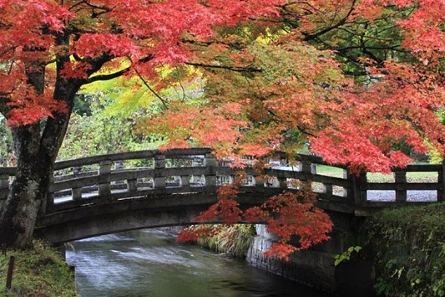
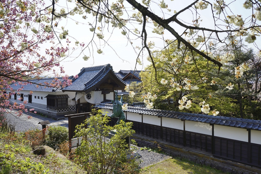
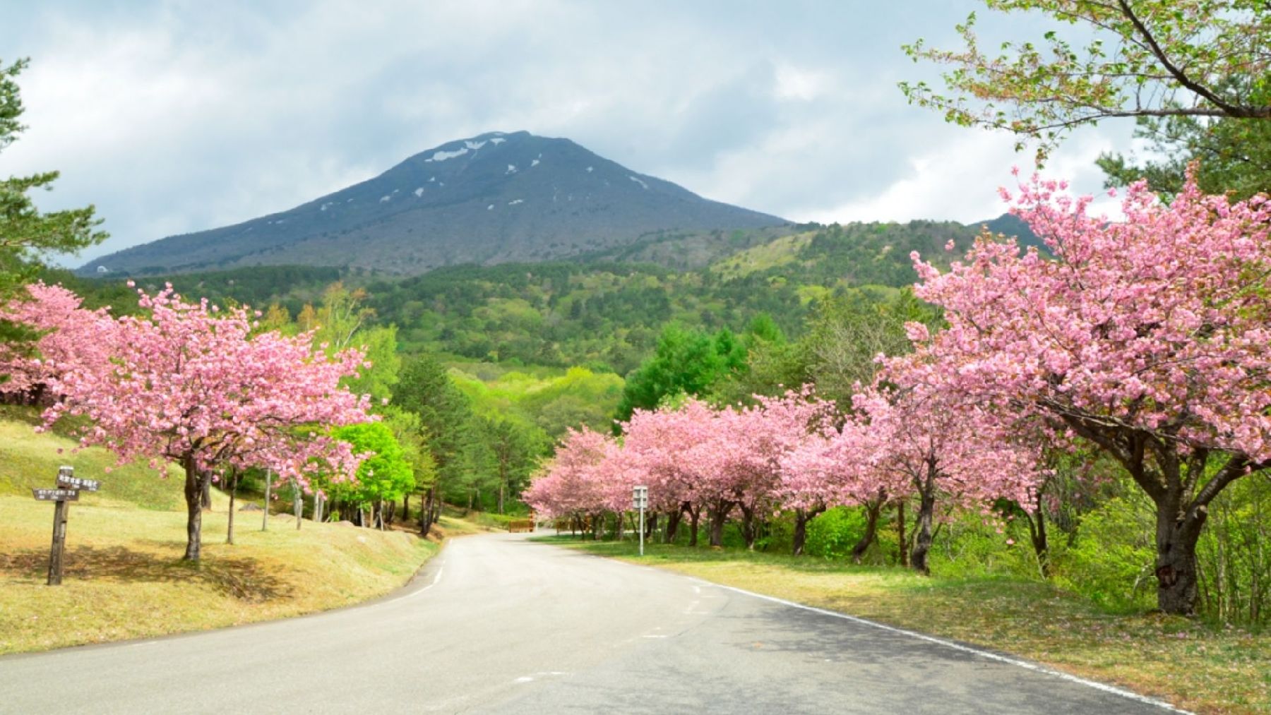
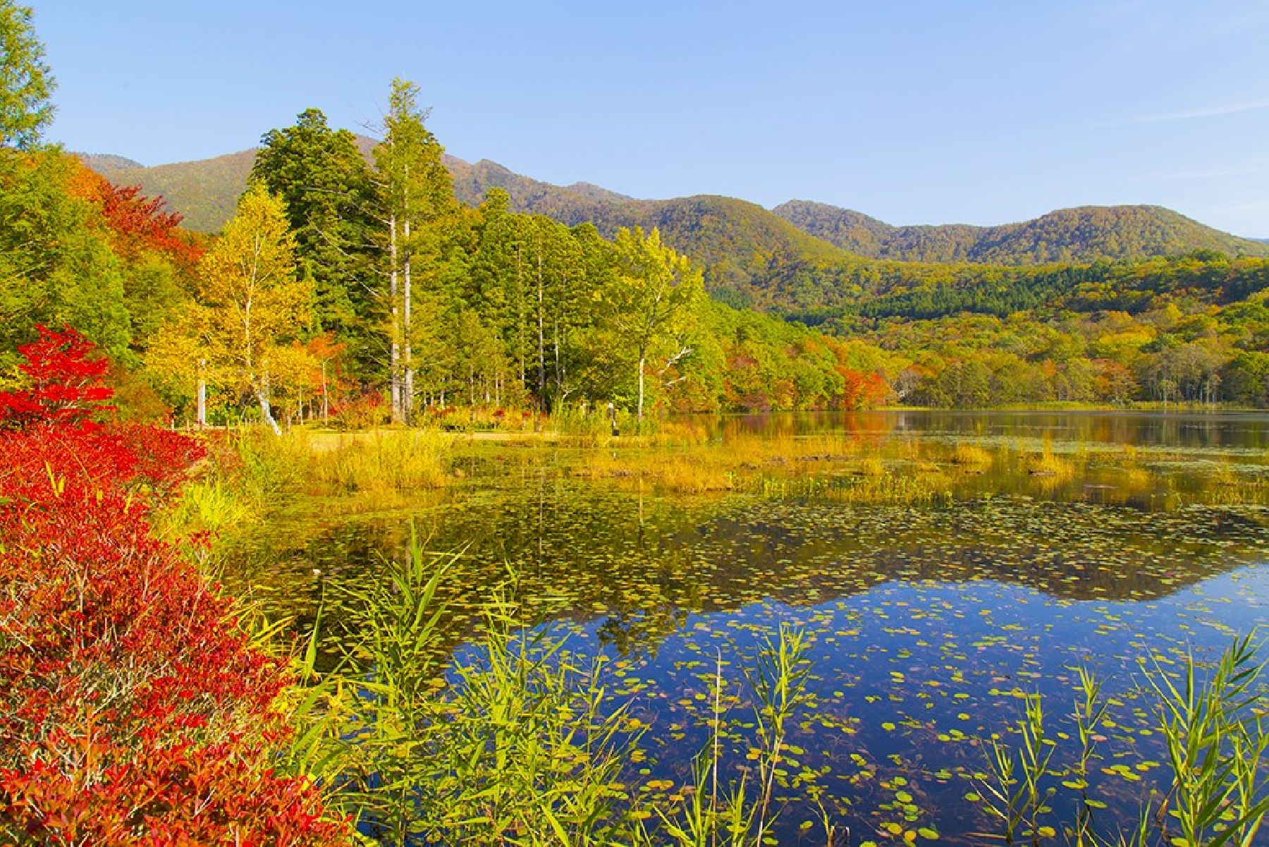
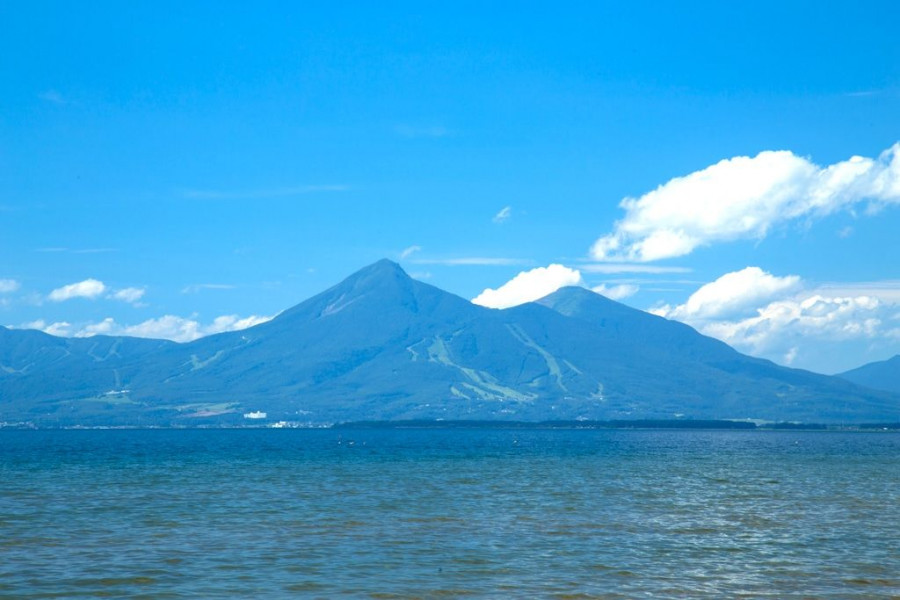
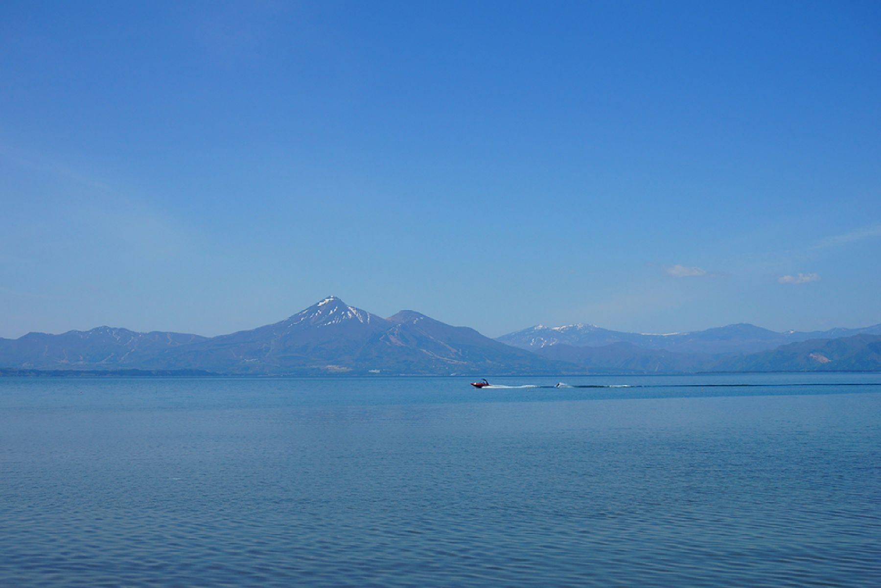
Related trips

Nearby

The World Glassware Hall
History & Culture

Aizu Bukeyashiki (Samurai Residence)

Aizu Bukeyashiki (Samurai Residence) is a historical open-air museum where visitors can learn about the history of Aizu and sample some of the specialty products of Fukushima.Stroll around the residences to take in traditional Japanese architecture, including the residence of Tanomo Saigo, the Aizu Domain's chief retainer, a magistrate's office, a tea ceremony house, a rice mill, and a warehouse (resource center).Visitors can also enjoy local specialty food at the onsite Kuyotei restaurant, and find specialty products from Aizu and other parts of Fukushima at Sato-Kobo Kokon, and enjoy hand-painting traditional toys and practicing Japanese archery, which is perfect for young kids.Besides such cultural enjoyment, the natural beauty of the spring cherry blossoms and the autumnal foliage are a major attraction for tourists.

The World Glassware Hall
Nature & Scenery

Tenkyodai Showa-no-Mori Park

Tenkyodai Showa-no-Mori Park (天鏡台・昭和の森公園) is a wide plateau close to Mount Bandai in Inawashiro Town, famous for its impressive views of Lake Inawashiro surrounded by lush greenery. East Asian and Somei Yoshino cherry blossom trees bloom spectacularly, typically from early to mid May, against the backdrop of the mountains. During autumn, the rows of colorful red and orange trees make for an unmissable sight. Visitors can follow the strolling paths and enjoy 30 or 60 minute hikes.From the viewing platform, don’t miss the incredible sights of lake Inawashiro and Mt. Bandai.Best season for sakura viewing (previous years): Early to Mid-May (dates vary each year).Please note that the park closes during winter (approximately from December until mid-April).

The World Glassware Hall
Nature & Scenery

Kannon-numa Forest Park

Kannon-numa Forest Park (観音沼森林公園) is a picturesque natural area in the Minamiaizu District of Southern Fukushima Prefecture.A wide variety of vegetation, flowers, and birds can be found at Kannon-numa Forest Park. There are nine walking trails, each offering unique sights. The main trail covers about 1.2 km and goes around the Kannon-numa swamp, which is one of the main highlights of the park. The park becomes transformed in each season, with cherry blossoms in spring and hydrangeas in the summer, and it is particularly popular with visitors during the autumn. The colorful trees reflected on the swamp’s waters make for a lovely sight, making it one of the main autumn attractions in the area. The best time to visit to see the autumn foliage is typically from late October to early November. There is also a shrine, Dake Kannondo, believed to have been built over 1,000 years ago.Located about 35 minutes from Ouchi-juku by car, this park is the perfect place to bask in the natural wonders of Shimogo Town. 

The World Glassware Hall
Nature & Scenery

Byobuiwa Crags

The Byobuiwa Crags (屏風岩) are a rock formation in Minamiaizu, in the Southern area of Fukushima Prefecture. The rocks have eroded through many years to their current shape. The crags are light in color, offering an interesting contrast with the blue of the gushing Ina river, and the vibrant colors of the surrounding foliage, creating a scenery that becomes particularly poignant during the autumn. Visitors can stroll the walking course around the crags, which takes approximately 20 minutes to be completed and includes several interesting picture spots.

You might also like

Kannonji-gawa River Cherry Trees
Nature & Scenery

Kannonji-gawa River Cherry Trees

Only a one-minute walk north of Kawageta Station (JR Ban-etsu West Line) is this beautiful 1 km-path along the banks of the Kannonji-gawa River. In the spring the path transforms into a spectacular tunnel of Yoshino cherry trees and weeping cherry trees. Kannonji-gawa River is perhaps the most fantastic place to see cherry blossoms in Fukushima Prefecture; the calming river and the lovely petals falling like snow are a sight that can’t be beat. The lush green bank contrasting with the pale pink blossoms creates an unforgettable scene. Altogether there are about 200 trees growing along the Kannonji-gawa River on both banks. Additionally, the river maintains its natural curves and bends as it hasn’t undergone any work to adapt its shape to the city surrounding it. It’s one of Fukushima’s most splendid and respected natural landscapes. Currently, the Kannonji-gawa River cherry trees rank number 11 of the best places to see cherry blossoms in the entire Tohoku region! While enjoying the delicate blossoms and the sweet, fresh air, visitors to Kannonji-gawa River can also enjoy some of the tasty food from street vendors available only during the cherry blossom season. We’d really recommend a springtime picnic right on the river bank with various yatai (food stand) delicacies. Be sure to come back during the evening when the trees are illuminated, and the river transforms into a magical dreamscape.

To-no-hetsuri Crags
Nature & Scenery

To-no-hetsuri Crags

A national natural monument, To-no-hetsuri Crags consists of tower-shaped cliffs overlooking Okawa River. Hetsuri is an Aizu word meaning "a cliff overlooking a river" or "a steep slope" in the local dialect.These strange-shaped cliffs are thought to be made of various types of rocks formed around 28 million years ago and feature deep cracks along the vertical joints. Thanks to trees growing between the white multi-layered rocks the view in autumn is quite spectacular. In spring and summer, the lush greens create a beautiful carpet down the rocks; in winter, the heavy snows make To-no-hetsuri Crags look otherworldly.The 200-meter long, natural cliff formation has alternating types of rocks that also include a relatively soft strata, which have been eroded by rain and wind, resulting in distinctive and eye-catching dips and curves in the rock face that resemble a forest of towers. Each of these tower-like rocks has its own name: Eagle Tower, Hawk Tower, Lion Tower, House Tower, Turret Tower, Nine-Ring Tower, Elephant Tower, Goma (fire ritual) Tower, Eboshi (tall hat worn by male aristocrats in the Heian Period) Rock, Folding Screen Rock, Stage Rock, and Sumo Arena Rock.Visitors to the area of To-no-hetsuri Crags can best enjoy the dynamic scenery by crossing the nearby suspension bridge. The suspension bridge offers a breathtaking sight of the river and cliff sides. At the foot of the cliff there is also a small shrine dedicated to the Bodhisattva of Wisdom. Another great way to enjoy To-no-hetsuri Crags is from the observatory neighboring the area where guests can view a panoramic scene of Okawa River, To-no-hetsuri Crags, and the suspension bridge. After enjoying the beautiful sight, head over to the local shopping area for restaurants and souvenirs.

Byobuiwa Crags
Nature & Scenery

Byobuiwa Crags

The Byobuiwa Crags (屏風岩) are a rock formation in Minamiaizu, in the Southern area of Fukushima Prefecture. The rocks have eroded through many years to their current shape. The crags are light in color, offering an interesting contrast with the blue of the gushing Ina river, and the vibrant colors of the surrounding foliage, creating a scenery that becomes particularly poignant during the autumn. Visitors can stroll the walking course around the crags, which takes approximately 20 minutes to be completed and includes several interesting picture spots.

Mt. Bandai
Nature & Scenery

Mt. Bandai

Originally known as Iwahashi-yama, literally a rock ladder to the sky, the renamed Mt. Bandai is no less impressive. Often referred to as 'Aizu's Mt. Fuji', Mt. Bandai is one of the 100 most famous mountains in Japan, and has even been selected as one of the top 100 geographic landmarks in Japan. In 2011, the mountain was certified as a geopark, which is a unified area with geological heritage and international significance, as defined by UNESCO. There are seven climbing routes for Mt. Bandai, with the trail starting at the Happodai trailhead being the most popular, and easiest route. From the Happodai trailhead, the 3.5 km route takes around 2 hours to reach the summit.The various routes range from 2 to 4 hours and from 3 to 7 km. At Koubou Shimizu, one of the mountain stops, there are two shops where trekkers can buy drinks, snacks, and souvenirs, but please note that there is no accommodation available. For many Buddhist mountain fanatics, Mt. Bandai holds a place of great significance. Enichi-ji Temple, located on the southwestern foot of Mt. Bandai, is a popular temple to visit nearby. The mountains situated around the temple make for a serene vista where one can feel the power of nature. Enichi-ji Temple was founded one year after Mt. Bandai erupted, in 807 C.E.; in the past, some superstitious people believed there was a connection between the eruption and the temple’s founding... Interestingly, Mt. Bandai used to be shaped more like the famous Mt. Fuji, but after a volcanic eruption in 1888, the shape changed to what we see today. It is thanks to that eruption that the mountain gained its rugged, sharp look and the Urabandai area behind Mt. Bandai was created. For non-hikers, the Bandaisan Gold Line is a popular sightseeing road that leads up the southwestern side and offers brilliant vistas of the foliage, especially in autumn when the colors change.

Top